|
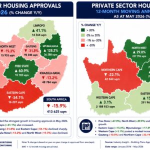
Within the variety of data visualisation solutions that Industry Insight offers, one of them is the mapping service. Whether you are interested in the building or civil sectors, or roads or water, we can map it all. Whether you are interested in Western Cape or Gauteng we can provide maps of the data from our project database of construction activity, be it out to tender out or the value of projects awarded.
The mapping service acts as an additional level of analysis that is complemented by our publications. What the mapping does is that it allows the client to get a visual overview of construction in South Africa, or a specific province. This greatly contributes to the capacity of contextualising construction. |